 Welcome!
Clean-flowing rivers & streams are hard to find these days, especially in the Chesapeake Bay watershed. Nestled in the gently rolling hills of south-central Pennsylvania, the Quittapahilla watershed drains a relatively small area but contributes a disproportionately large share of agricultural & urban pollutants to the Bay. The Quittapahilla Watershed Association is dedicated to improving the water quality of the watershed and to raising public awareness about its importance, locally & regionally.
Ours is an aptly designated "impaired watershed".** The source of the mainstem, Quittapahilla Creek, burbles out of the ground just east of Lebanon PA (pop. 26,000) and flows straight west through the heart of the city in an oversize concrete channel known locally as The Hazel Dike. The creek drains every street in Lebanon. It keeps flowing west, parallel to a heavily trafficked commercial & residential corridor (Route 422) before passing a large quarry operation (Pennsy Supply) and entering mixed farmland, pasture & woodlots. Seven primary tributaries and scores of lesser, unnamed tributaries flowing through grain & dairy farms accumulate the lion's share of the watershed's non-point pollution. Its 89 miles of streams — 98% of which are impaired — drain 49,500 acres (77 square miles, 200 square kilometers) into Swatara Creek, the Susquehanna River, the Chesapeake Bay & the Atlantic Ocean.
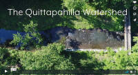 For a lovely introduction to our watershed,
see
this short
video produced by QWA member Kelly Cottingham.
For a lovely introduction to our watershed,
see
this short
video produced by QWA member Kelly Cottingham. Why does the Quittapahilla watershed matter? It matters locally because without it, our quality of life in Lebanon County PA would be dramatically diminished. The county's largest & most densely populated areas get their drinking water directly from the Swatara Creek, into which the Quittie & its tributaries flow. Lebanon City, Annville, Palmyra, and other townships & boroughs have invested millions of dollars in state-of-the-art sewage treatment plants that discharge treated sewage-water directly into the Quittie & its main branches. Fishers, hikers, runners, walkers, schoolkids, and many other residents find in the natural areas surrounding Quittie Creek & its tributaries an enjoyable & necessary respite from the hectic demands of everday life. It matters regionally because what's in the Quittie flows into the Chesapeake Bay, a treasured national resource that generates hundreds of millions of dollars annually, is worth hundreds of billions of dollars in real estate & property values and in the businesses it supports, and upon which hundreds of thousands of jobs depend. It matters because all creeks & rivers & watersheds matter.
.jpg) Teachers take note: the Quittapahilla
Educational Wetland Preserve is ready to be
discovered and explored!
Click here for details.
Teachers take note: the Quittapahilla
Educational Wetland Preserve is ready to be
discovered and explored!
Click here for details.NEW! Water Quality Portal. Check out our freshly-created and still-in-progress QWA Water Quality Portal, where we expect to house and make publicly available the data we are generating in our Monitoring Program: The URL is here: https://quittiedata.org
Get Involved!
Left: Signs on Rt. 422 (Main St.) on the west end of Annville reminding motorists & residents that Quittapahilla Creek flows to the Chesapeake Bay. The lower sign, designating Annville as a "Chesapeake Bay Partner Community," was awarded by the Chesapeake Bay Trust thanks to QWA efforts.
________________________________________
** "Studies conducted by PADEP in the 1980’s and 1990’s indicated that the aquatic resources in the Quittapahilla Creek Watershed are impaired. The mainstem, as well as all of the major tributaries to Quittapahilla Creek are listed as impaired in the 303(d) listings. The 2000 305(b) Report prepared by PADEP indicates that there are 88.9 miles of stream in the Quittapahilla Creek Watershed. Only 1.82 miles of stream (2%) were found to support designated aquatic life uses. The recently released Total Maximum Daily Loads (TMDLs) Report (PADEP, 2000) cites excessive sediment and nutrient levels as a major water quality problem in the Quittapahilla Creek Watershed. The report indicates that these pollutants are causing increased algae growth, large accumulations of fine sediments on the streambed, and degradation of in-stream habitat." Excerpt from conclusions in section on "Water Quality Assessment" in Rocky Powell, Findings Report, Volume I, 2006, p. 283 — housed on the Studies & Documents page of this website.
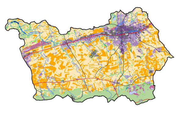
Above: Land Use Map of the Quittapahilla Watershed, adapted from Powell, vol. 1 (2006), Plate 8. CAP