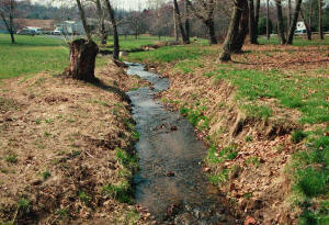
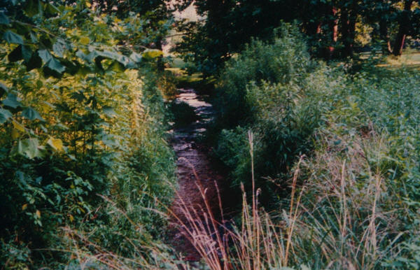
 There are
about as many ways to protect creeks &
waterways, stabilize their banks, minimize
erosion, and prevent or limit pollution & contamination
from point & nonpoint sources as there are creeks &
waterways to protect and sources to protect them
from. (Right: Stream in a
residential area where landowner mowed to top of
stream banks)
There are
about as many ways to protect creeks &
waterways, stabilize their banks, minimize
erosion, and prevent or limit pollution & contamination
from point & nonpoint sources as there are creeks &
waterways to protect and sources to protect them
from. (Right: Stream in a
residential area where landowner mowed to top of
stream banks)
In the eyes of QWA Board member Dr. Alan Wood, who's worked for & with the USDA's NRCS for many years, the premier guides to stream restoration are produced by the US Dept of Agriculture's Natural Resources Conservation Service, accessible via the following link: http://go.usa.gov/BvNA.
Most useful for our purposes are Handbook 653 on Planning, and Handbook 654 on Design. Below we provide links to PDF files of the following plucked from the NRCS website:
NRCS National Engineering Handbook 653, "Stream Corridor Restoration: Principles, Processes, and Practices" (published October 1998, revised August 2001).
NRCS National Engineering Handbook 654, "Stream Restoration Design" (issued August 2007).
Preface
Chapter 1 - Introduction
Chapter 2 - Goals, Objectives, and Risks
Chapter 3 - Site Assessment & Investigation
Chapter 15 - Project Implementation
Chapter 16 - Maintenance & Monitoring
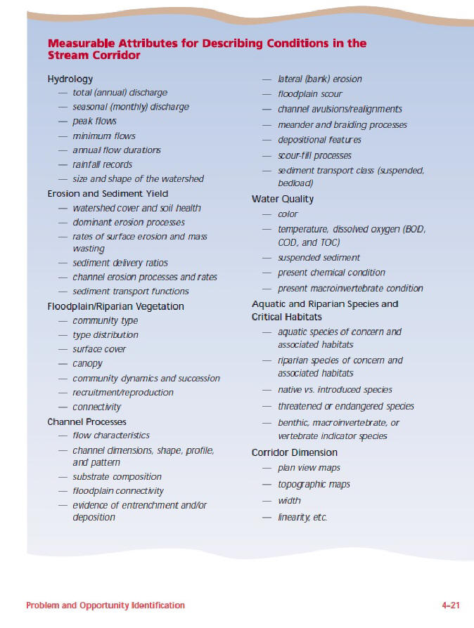
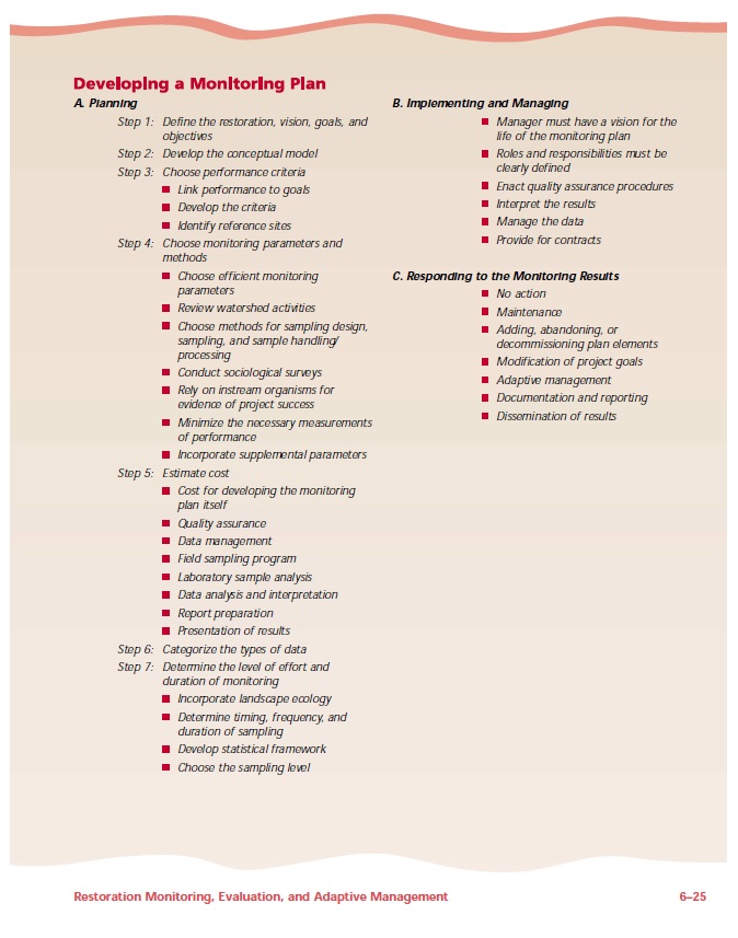
Especially useful for our purposes are pages 4-21 & 6-25 in NEH-653. Below we reproduce these pages as JPEG images:
The foregoing covers the broadest sweep of issues relating to stream restoration. In what follows we narrow the discussion to focus on Best Management Practices (BMPs) for protecting creeks & waterways. Such BMPs generally fall into three main types:
• Agricultural BMPs
• Urban BMPs
• Stream Stabilization & Restoration BMPs
In what follows we offer brief discussions of each of these practices, starting with the last.
 Stream Stabilization
& Restoration BMPs
Stream Stabilization
& Restoration BMPs
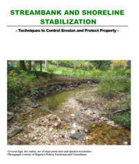
In many ways these are the simplest & least complicated of the Best Management Practices designed to protect streams & waterways. To introduce the subject, we turn to a handy & authoritative 22-page guidebook published in April 2011 by the Watershed Protection Branch of the Georgia Environmental Protection Division, a branch of the Georgia Department of Natural Resources. The guidebook includes easy-to-understand discussions & diagrams of many of the practices & techniques used by professionals in the field today to stabilize streambanks & shorelines (click on the link above or the cover, above right, to access the PDF file, 2.9 MB).
We also need to distinguish between traditional and geomorphic approaches to stabilizing streambanks & restoring streams & wetlands. More traditional approaches are commonly associated with engineered channels with uniform profiles designed to convey all water flows, such as Flynn's Hazel Dike in Lebanon. As emphasized in the QWA's 2013 Watershed Implementation Plan (WIP), "This engineered approach invites long-term problems due to the negative feedback mechanisms inherent in all stream systems. These channels are generally devoid of habitat" (p. 26). The 2013 WIP goes on to emphasize the importance of implementing a geomorphic approach:
"[The geomorphic] approach is system-oriented and works with, rather than against, the natural processes that shape and maintain stream channels. Restoration efforts are focused on: restoring a stable, self-maintaining channel form; reestablishing the critical interactions between the stream and adjacent riparian areas; restoring the natural functions of floodplains; modifying channel and floodplain maintenance practices that are inconsistent with these objectives; and minimizing the effects of land use by relocating structures from high hazard areas, and adopting land use controls throughout the watershed that are based on landscape capabilities." (QWA Watershed Implementation Plan, May 2013, p. 27)
Readers seeking a more extensive discussion of these issues are invited to consult the QWA's Aug. 2018 WIP, housed toward the top of the Studies & Documents page of this website.
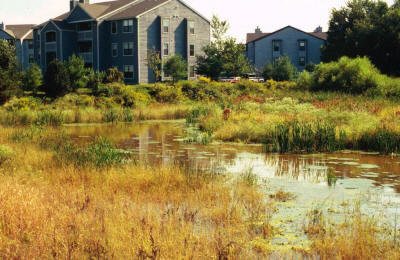 Protecting
& restoring wetlands & floodplains comprise another crucial
dimension of stream restoration & management. Major flood events — most recently for our
watershed, Hurricane Agnes in 1972 and Tropical
Storm Lee in 2011 — remind us of the importance of
maintaining wetlands & floodplains for absorbing
excess rainfall and limiting flood damage and
sediment flows downstream. (Right:
stormwater wetlands in a residential subdivision)
Protecting
& restoring wetlands & floodplains comprise another crucial
dimension of stream restoration & management. Major flood events — most recently for our
watershed, Hurricane Agnes in 1972 and Tropical
Storm Lee in 2011 — remind us of the importance of
maintaining wetlands & floodplains for absorbing
excess rainfall and limiting flood damage and
sediment flows downstream. (Right:
stormwater wetlands in a residential subdivision)
Stabilizing streambanks, protecting wetlands & floodplains, and managing flows of water to limit erosion and protect public & private property comprise one set of challenges. A related sphere, especially in our watershed, is minimizing pollution & contamination from runoff from nonpoint sources, especially agricultural chemicals (fertilizers, pesticides, herbicides); livestock (mainly cattle defecating in streams); urban zones (plastic, electronic waste, hazardous household waste & other types of refuse that gets washed into waterways during rainstorms); construction sites; leaking septic tanks; and other sources. Here we turn to the second main set of Best Management Practices listed above — those relating to agriculture.
Agricultural BMPs
As noted in the QWA's August 2018 WIP, agriculture contributes the majority of sediment and nutrient pollution to the Quittapahilla Watershed (p. 1). To address these issues, a wide variety of agricultural BMPs are recommended, most prominently:
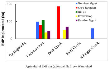 • Cropland Protection
• Conservation Tillage
• Strip Cropping / Contour Farming
• Agricultural Land to Forest
Conversion
• Agricultural Land to Wetland
Conversion
• Nutrient Management
• Grazing Land Management
• Terraces and Diversions
Each of these best management practices is discussed in greater detail in the August 2018 WIP.
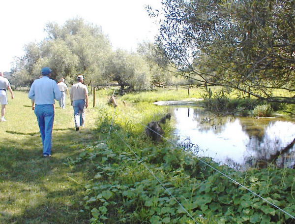
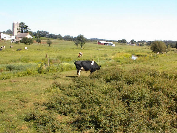
For grazing land management, the challenge isn't that the stream protection practices are hard to understand or costly to implement. Most are pretty simple and cheap: installing fencing to prevent livestock from gaining direct access to waterways, and planting riparian buffers of trees & other vegetation along streambanks to help keep livestock away. The images below show fencing that the Quittapahilla Watershed Association helped to install on a farm in the Hammer Creek in Lancaster County back in the year 2000. It's not complicated. All it takes is the cooperation of the landowner, sufficient knowledge to know what needs doing, and the labor & materials to do it. Unless we're talking about thousands of linear feet of fencing, for most farmers it's not prohibitively expensive and doesn't take away too much grazing or cropland.
Below: Fencing installed along Hammer Creek on a farm in Lancaster County to prevent livestock from gaining direct access to the creek.
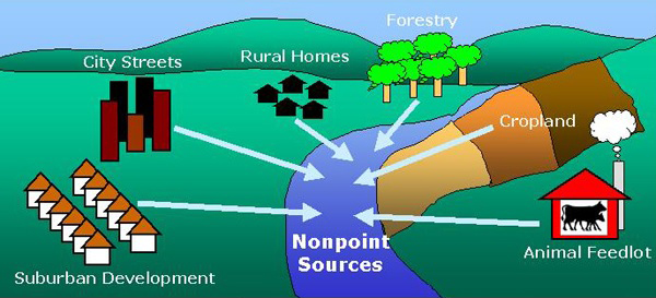
For agricultural chemicals, the challenges are far more daunting. For sound economic reasons, most farmers don't want to stop using fertilizers, herbicides & pesticides, and there is no cheap or easy way to keep these chemicals from leaching into the watershed. The simplified schematic diagram below, taken from the website of the National Oceanic & Atmospheric Administration, only begins to suggest the complexity of the problem of nonpoint sources of pollution like agricultural chemicals:
The same is true of the other major source of nonpoint pollution contaminating the Quittapahilla watershed: urban trash — everything from discarded plastic bottles, styrofoam coffee cups, chip bags & candy wrappers to toys, lighters, cigarrette butts, and a dizzying variety of other objects & substances, including electronic waste (batteries, wires, circuit boards); pharmaceutical waste (prescription & non-prescription drugs); household hazardous waste; and more. Here we turn to the third major type of BMP:
Urban BMPs
Urban stream restoration is made especially daunting by the variety of types of point & non-point pollution typically discharged into streams in urban areas. Specific areas of concern include:
 Electronic
waste: In e-waste one typically
finds large quantities of epoxy resins, fiberglass,
PCBs, PVC (polyvinyl chlorides), thermosetting
plastics, lead, tin, copper, silicon, beryllium,
aluminium, cadmium, mercury, and thallium. In trace
amounts one finds americium, antimony, arsenic,
barium, bismuth, boron, cobalt, europium, gallium,
germanium, gold, indium, lithium, manganese, nickel,
niobium, palladium, platinum, rhodium, ruthenium,
selenium, silver, tantalum, terbium, thorium,
titanium, vanadium, and yttrium. Most of these
elements, compounds & chemicals are toxic to most
organisms (Photo at right: remains
of a severely corroded CD player plucked out of the
Quittie in July 2011, one of many such examples of
e-waste contaminating our local waterways)
Electronic
waste: In e-waste one typically
finds large quantities of epoxy resins, fiberglass,
PCBs, PVC (polyvinyl chlorides), thermosetting
plastics, lead, tin, copper, silicon, beryllium,
aluminium, cadmium, mercury, and thallium. In trace
amounts one finds americium, antimony, arsenic,
barium, bismuth, boron, cobalt, europium, gallium,
germanium, gold, indium, lithium, manganese, nickel,
niobium, palladium, platinum, rhodium, ruthenium,
selenium, silver, tantalum, terbium, thorium,
titanium, vanadium, and yttrium. Most of these
elements, compounds & chemicals are toxic to most
organisms (Photo at right: remains
of a severely corroded CD player plucked out of the
Quittie in July 2011, one of many such examples of
e-waste contaminating our local waterways)
 Pharmaceutical
waste: It would be impossible to
list all the pharmaceutical products that currently
pose a threat to the Quittapahilla watershed & other
waterways in North America & around the world.
Flushing that old medicine down the toilet? Since most wastewater treatment plants do not test
for or remove pharmaceuticals, flushing those old
pills down the toilet is no different than walking
down the local creek and pitching them in. Suffice
it to say that the list of potentially hazardous
pharmaceuticals is as long as the threat they pose
is big, and that ample indirect evidence exists to
characterize the Quittapahilla watershed as impaired
by pharmaceutical waste. What indirect evidence?
Mainly abundant quantities of empty prescription
drug bottles (most without labels) &
over-the-counter drug containers (e.g., aspirin,
Tylenol, cough syrups, antibiotics) & discarded
syringes, as shown by the photos published by &
"artifacts" on exhibit at the Quittapahilla Creek
Garbage Museum in Annville.
Pharmaceutical
waste: It would be impossible to
list all the pharmaceutical products that currently
pose a threat to the Quittapahilla watershed & other
waterways in North America & around the world.
Flushing that old medicine down the toilet? Since most wastewater treatment plants do not test
for or remove pharmaceuticals, flushing those old
pills down the toilet is no different than walking
down the local creek and pitching them in. Suffice
it to say that the list of potentially hazardous
pharmaceuticals is as long as the threat they pose
is big, and that ample indirect evidence exists to
characterize the Quittapahilla watershed as impaired
by pharmaceutical waste. What indirect evidence?
Mainly abundant quantities of empty prescription
drug bottles (most without labels) &
over-the-counter drug containers (e.g., aspirin,
Tylenol, cough syrups, antibiotics) & discarded
syringes, as shown by the photos published by &
"artifacts" on exhibit at the Quittapahilla Creek
Garbage Museum in Annville.
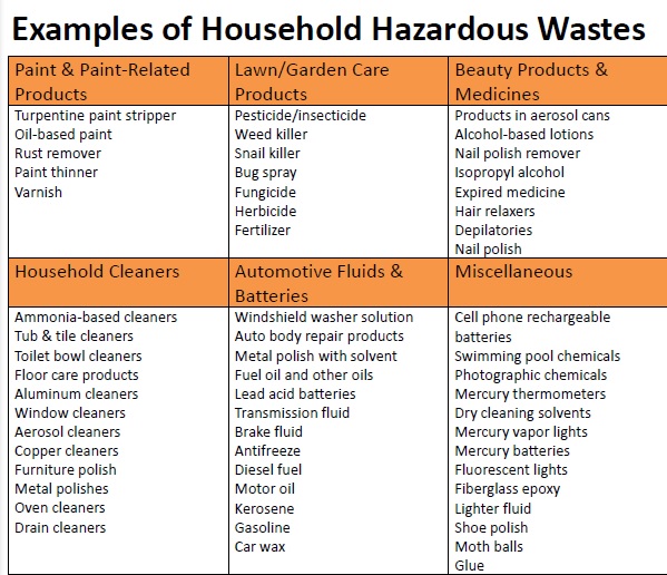
Household Hazardous Waste: The chart below offers a simplified synopsis of the major types of hazardous household waste (HHW) that typically contaminate urban creeks & rivers like Quittapahilla Creek:
In the Chesapeake Bay watershed today, the main issues relating to creek protection center on the efforts of states & local governments to comply with the provisions of the Clean Water Act of 1987 — a living law for which each year the federal EPA issues new regulations, standards & mandates that state & local governments have to comply with. A major issue here is MS4, or Municipal Separate Stormwater Sewer Systems — federal requirements for managing stormwater that must met by state & local governments across the watershed. The Wikipedia entry on the Clean Water Act is a very good place to start. A section of the EPA's website offers detailed discussions of MS4 and Clean Water Act related issues. This website's page on the Lebanon County Clean Water Alliance (LCCWA) surveys the county's history of foot-dragging on meeting MS4 requirements, and documents what's being done locally now.
 As even this brief survey suggests,
the threats confronting our waterways are dauntingly
huge, diverse & complex. So too are the
challenges of protecting them. The resources at our
disposal, on the other hand, are not so huge.
As even this brief survey suggests,
the threats confronting our waterways are dauntingly
huge, diverse & complex. So too are the
challenges of protecting them. The resources at our
disposal, on the other hand, are not so huge.
As a local non-profit organization run by a handful of concerned citizens, the Quittapahilla Watershed Association can only do so much. Our main focus has been using state & federal grant monies for stabilizing streambanks, installing riparian buffers, and working with local farmers & property owners to address specific issues relating to the watershed. Our record in this sphere is strong & impressive, and we're proud of what we've accomplished.
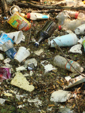
We've been less effective in addressing larger issues relating to creek protection, because the sad fact is that those issues are a whole lot bigger than we are. We can't stop or even put much of a dent in nonpoint agricultural runoff, or in pharmaceutical or household hazardous waste, even within our little watershed. But we can work harder to educate the public about these issues. Raising public awareness is an essential precondition for creating the political will necessary to address the many problems confronting our waterways — not only in Lebanon County but across Pennsylvania & the USA & beyond. Ultimately these are political issues and can only be effectively addressed if there exists a critical mass of political will — at local, statewide, regional, national & transnational levels — to do it. Raising public awareness locally means working with public officials, businesses, farmers, community leaders, school groups, church groups, and other community organizations to educate people about the challenges we face and the most viable solutions — something we plan to do more of in the months & years ahead. (Above right: typical accumulation of trash along Quittie Creek, May 2011)
Meantime we'll continue in our efforts to protect our local waterways as best we can with the limited resources available. If you want to lend a hand, please be in touch! Fact is, we could really use your help.
Above: Same stretch of creek that appears at the top-right of this page, of the landowner who mowed right up to the edge of the streambanks, two growing seasons after mowing practices were modified.