Gingrich Run
Where can I find it? Gingrich Run begins south of Rt. 322 just east of South Mountain Pleasant road, as seen on the Google Map below:
View Gingrich Run Mouth in a larger map
The source of Gingrich Run is formed by the confluence of two even smaller spring-fed runs — one that originates on the land owned byThousand Trails-Resort Camping, and the other that springs from the land owned by Weaber Lumber Co. southwest of Rt. 241. Gingrich Run flows generally northwest through grain & dairy farms, crossing under Rt. 322 directly east of Meadow Lane. Flowing northwest past Rover Airport (to the south) and cultivated fields, cattle & horse pastures, and farmsteads, it merges with Killinger Creek about one mile north of Rt. 322 and half a mile west of Louser Road.
Drainage Area: 6.01 square miles
Stream Length: approx. 2.3 miles
Elevation at Origin: 502.6 ft.
Elevation at End: 413.4 ft.
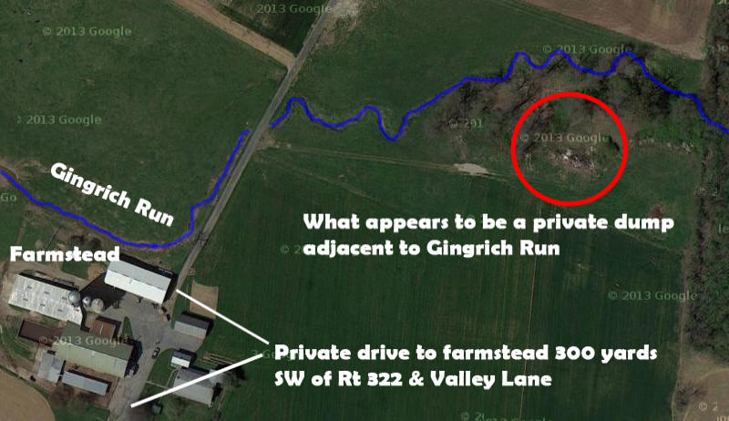
Modified Google Map of a short stretch of Gingrich Run just south of Horseshoe Pike (Route 322), about 300 yards southwest as the crow flies from the intersection of Rt 322 & Valley Lane. The image seems to show a private dump adjacent to Gingrich Run, and conveys a sense of the agricultural lands drained by the Quittie's main tributaries.
For additional images of Gingrich Run & the other waterways comprising the Quittapahilla watershed, see the Photos & Images page.